


For the discerning property investor, due diligence is a non-negotiable ritual. We scrutinise zoning maps, pore over LIM reports, and analyse demographic shifts with a forensic eye. Yet, there is one profoundly underutilised due diligence tool that offers a perspective no spreadsheet ever could: the private helicopter tour. While it may seem an extravagant indulgence, viewing a potential investment landscape—quite literally—from 1,000 feet provides a strategic, data-gathering vantage point that is both unique and invaluable. In New Zealand’s topographically diverse and often geographically constrained markets, this aerial perspective can reveal hidden opportunities and systemic risks invisible from the ground. This article analyses the private helicopter tour not as a luxury experience, but as a sophisticated, high-value component of a comprehensive investment strategy.
The Strategic Investor's Guide to Aerial Due Diligence
Approaching a helicopter tour with an investor's mindset transforms it from a scenic flight into a targeted reconnaissance mission. The objective is not passive sightseeing but active intelligence gathering. The key is meticulous preparation and a clear operational framework.
Step 1: Define Your Investment Thesis & Flight Objectives
Before contacting a charter company, crystallise what you need to see. Are you assessing the masterplan integration of a new large-scale subdivision? Evaluating the topographical challenges and access routes for a potential rural-agri investment? Or surveying the urban sprawl patterns and infrastructure corridors around a regional centre? Your specific thesis dictates the flight path. For instance, if analysing a coastal development, you must observe tidal patterns, erosion markers, and the relationship between housing and the coastal marine area.
Step 2: Select the Right Operator & Craft a Bespoke Flight Plan
Not all helicopter tours are created equal. You require an operator experienced in bespoke, non-standard routes. Communicate your professional intent clearly. A reputable operator will assign a pilot familiar with local geography who can act as an informal guide, pointing out flood plains, geological features, or recent development zones. Crucially, you must secure permission for low-level passes over areas of interest—this is not a standard scenic route and requires prior arrangement and safety briefings.
Step 3: The In-Flight Analysis Framework
During the flight, systematically assess the landscape through an investor's lens. Use a structured framework to ensure consistent analysis:
- Macro-Topography & Natural Boundaries: Identify how mountains, rivers, and coastlines naturally constrain or direct growth. Observe where the urban footprint is forced to stop or leapfrog.
- Infrastructure Corridors & Connectivity: Trace state highway expansions, port developments, and three-waters infrastructure. Note the proximity and integration of your target asset with these lifelines.
- Land-Use Patterns & Zoning Realities: See the actual on-the-ground land use versus district plan maps. Spot informal subdivisions, unauthorised land use, or areas ripe for rezoning based on existing development pressure.
- Environmental & Geotechnical Risks: Visually assess slip scars on hillsides, flood-prone river plains, or coastal erosion. This provides a visceral understanding of long-term holding risks that contour lines on a map can obscure.
Step 4: Post-Flight Synthesis & Data Integration
The real value is created after landing. Immediately debrief and annotate photographs and video with your observations. Correlate your aerial insights with hard data. For example, if you noted severe coastal erosion near a proposed development, cross-reference with the regional council’s coastal hazard maps and NIWA’s sea-level rise projections. This synthesis creates a powerful, multi-layered investment thesis.
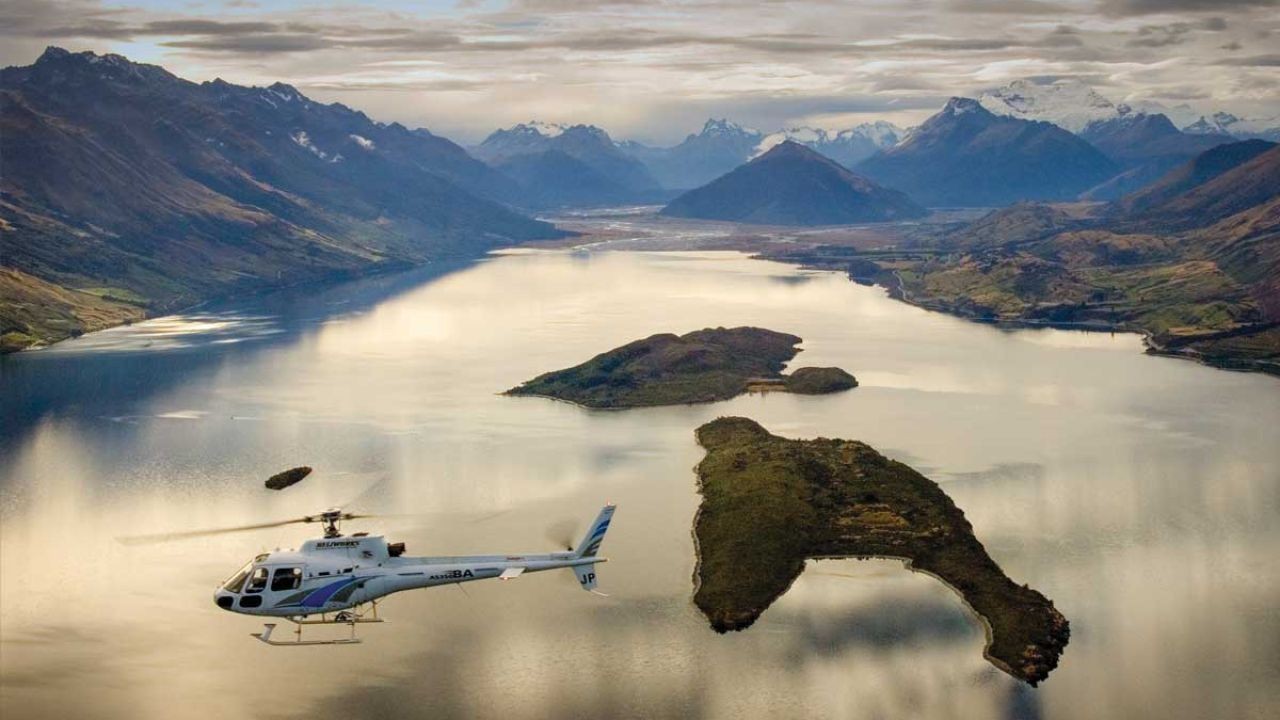
Case Study: Aerial Insight in the Queenstown Lakes District
Problem: In 2021, a syndicate was considering a significant land banking opportunity on the periphery of a major Queenstown satellite settlement. Ground due diligence showed promising zoning and infrastructure plans. However, the terrain was complex, and the true scale of competing developments in the basin was difficult to grasp from road level. The syndicate faced a critical, high-cost decision with incomplete spatial awareness.
Action: The lead investor commissioned a 90-minute private helicopter tour with a specific flight plan: to orbit the entire basin, focus on the subject land's topography, and then follow the arterial transport routes to the main urban centre and airport. The pilot, a local with decades of experience, provided commentary on historical flooding in certain valleys and pointed out several large-scale, yet-to-be-announced earthworks projects on neighbouring properties.
Result: The aerial view revealed two decisive factors. First, the subject land was far more isolated by rugged terrain than maps suggested, implying higher-than-anticipated servicing costs. Second, they identified at least three other major developments of a similar scale already underway, suggesting future oversupply and intensified competition for buyers and construction resources. The syndicate quantified the potential servicing cost overrun and modelled the impact of increased competitive supply.
Takeaway: The aerial reconnaissance cost approximately $2,500 NZD. It directly informed a decision to withdraw from a $12 million NZD land purchase, potentially saving millions in stranded capital and poor ROI. The lesson for New Zealand investors is clear: in topographically complex and fast-growing markets like Queenstown, Taupō, or Wanaka, a few thousand dollars on aerial due diligence can de-risk millions in investment capital. It provides context that ground visits and desktop studies simply cannot match.
The Critical Debate: Prudent Expenditure or Unjustifiable Extravagance?
This strategy invites a natural and healthy scepticism. Let's contrast the two perspectives.
✅ The Advocate's Perspective: A High-Value Risk Mitigation Tool
Proponents argue this is a classic case of "spend money to save money." In the context of a multi-million dollar property transaction, a $1,500-$3,000 helicopter charter is a negligible percentage of the total cost but can illuminate deal-breaking issues. It is the ultimate form of seeing the "big picture," literally and figuratively. For large rural or development sites, it is often more time and cost-effective than days of difficult ground surveying. The visual evidence gathered can also be powerful for securing buy-in from partners or financiers.
❌ The Critic's Perspective: An Unnecessary Cost in a Data-Rich World
Sceptics counter that we live in an era of unprecedented data accessibility. High-resolution satellite imagery (Google Earth, Nearmap), LiDAR data, GIS zoning layers, and drone surveys are all available at a fraction of the cost. They argue that a helicopter tour is a subjective, fleeting experience that lacks the analytical rigour of quantifiable geospatial data. The cost, while small relative to the deal, is still a direct hit to the bottom line that could be avoided with more thorough desk-based research.
⚖️ The Expert Middle Ground: A Targeted Tool for Specific Scenarios
The prudent conclusion is that aerial due diligence is not for every transaction. It is a specialised tool with a specific application. It delivers maximum value in the following New Zealand-specific contexts:
- Evaluating large-scale (>50ha) rural or development land with complex topography.
- Assessing regions with significant natural hazard profiles (coastal, floodplain, steep land).
- Understanding the interconnectedness of multiple sites or a region’s growth pattern.
For a standard residential investment in an established suburb, it is indeed an overkill. The key is to view it as a complementary layer to existing data, not a replacement. The visceral, holistic understanding it provides can contextualise and give meaning to the raw GIS data.
Future Forecast: The Democratisation of Aerial Intelligence
The future of this practice lies in technological integration. While helicopter tours will remain the premium option for their flexibility and human-guided insight, their role will evolve alongside advanced drones and AI-powered geospatial analytics. We foresee a hybrid model emerging within the next five years. Investors may first use AI to analyse satellite trends—such as vegetation change or construction activity—to identify areas of interest. They would then deploy a drone for detailed, low-altitude photogrammetry of specific sites. The private helicopter tour would then be reserved for the final, strategic overview of the most promising short-listed opportunities, providing the crucial regional context that drones cannot efficiently capture.
This trend aligns with broader movements in New Zealand's economy. The government's National Policy Statement on Urban Development (NPS-UD) is forcing high-growth councils to enable more dense housing. Understanding the true spatial implications of this policy—where density can be viably intensified—is an aerial intelligence challenge. Furthermore, with the Reserve Bank of New Zealand's (RBNZ) climate change stress tests now requiring banks to assess physical climate risks to their portfolios, there will be increased demand for sophisticated, visual verification of long-term environmental hazards—a task for which aerial reconnaissance is uniquely suited.
Common Myths and Costly Mistakes to Avoid
Myth 1: "It's just a fancy sightseeing trip." Reality: Without a pre-defined analytical framework and specific objectives, it absolutely can be. The value is not in the flight itself but in the investor's disciplined approach to planning, observation, and post-flight data synthesis. Going in without a checklist is the single biggest mistake.
Myth 2: "All the information is available online for free." Reality: While data is abundant, context is not. Online maps are static and often outdated. A helicopter provides real-time, dynamic observation of traffic flows, construction progress, and environmental conditions that no satellite image can match. It reveals the relationships between features.
Myth 3: "This is only for billionaires and large funds." Reality: For a syndicate of five investors considering a $5 million development site, a $2,500 charter is $500 per person—a trivial cost per head for the insight gained. It's about scaling the tool to the scale and risk profile of the deal.
Costly Mistake: Failing to Brief the Pilot. Your pilot is an untapped local expert. The mistake is treating them as just a driver. The solution is to brief them thoroughly on your investment goals beforehand. A good pilot who understands what you're looking for will actively point out relevant features you might miss.
Costly Mistake: Ignoring Weather and Timing. Scheduling a flight for mid-day in summer can lead to harsh light and poor visibility. The solution is to book for early morning or late afternoon for softer light and longer shadows, which reveal topographic detail more clearly, and to have a flexible schedule to accommodate ideal weather windows.
Final Takeaways & Strategic Action Plan
- 🔍 Due Diligence Layer: Treat aerial reconnaissance as a critical, high-level layer in your due diligence process, not a replacement for ground work or desk research.
- 🎯 Targeted Application: Deploy this tool selectively for large, topographically complex, or regionally significant investments where spatial context is a major factor in the risk/reward equation.
- 📊 Framework is Key: The value is extracted through meticulous pre-flight planning and post-flight data integration. Go in with a checklist and correlate observations with hard data.
- 💡 Insider Insight: Your helicopter pilot is a potential source of invaluable local, non-public knowledge. Brief them fully to unlock this value.
- ⚖️ Cost-Benefit Analysis: Weigh the charter cost (typically 0.05% - 0.1% of a major deal's value) against the potential to identify a multi-million dollar risk or opportunity.
People Also Ask (PAA)
What is the typical cost of a private helicopter tour for due diligence in NZ? Costs vary by region and flight duration but typically range from $1,500 to $3,500 NZD for a 60-90 minute bespoke charter. This is often charged per flight, not per person, making it cost-effective for investor syndicates.
Are there legal restrictions on where you can fly a helicopter for this purpose? Yes. Pilots must adhere to Civil Aviation Rules (CARS). Low flying over urban areas or private property requires careful planning and often prior permission. A professional charter operator will manage all regulatory and safety requirements.
How does this compare to using a drone for site analysis? Drones are excellent for detailed, low-altitude inspection of a specific site. Helicopters provide the regional context, covering vast areas quickly and offering a human-guided, strategic overview. They are complementary tools used at different stages of analysis.
Related Search Queries
- helicopter due diligence New Zealand property
- cost of private helicopter charter NZ South Island
- aerial land assessment investment strategy
- Queenstown property development helicopter tour
- best helicopter companies for scenic flights NZ
- how to assess rural land from the air
- drone vs helicopter for property inspection
- New Zealand topographic analysis for investors
Final Takeaway & Call to Action: In an investment landscape where marginal gains are fiercely contested, and unseen risks are catastrophic, the strategic advantage lies in superior information. A private helicopter tour, when executed with analytical rigour, is not a luxury—it is a sophisticated data-gathering platform that provides a competitive edge in understanding the complex New Zealand terrain. Before you commit to your next major land-based investment, ask yourself: have I truly seen the whole picture? The answer, and your next strategic move, may well be waiting at 1,000 feet.
For the full context and strategies on How to Experience a Private Helicopter Tour Over New Zealand – How to Get Ahead Faster in NZ, see our main guide: How New Zealand Businesses Use Vidude Grow Locally.